🗺️ India and Its Neighbours

Class 5 • Social Studies

Meet the nine countries that live next door to India.

👆 Tap a button to jump to that section. The blue H · Quiz button opens the chapter quiz.

🎯 Section A: Learning Objectives

🎯 What you will learn

After this lesson you will be able to:

  1. Find India and its nine neighbours on a map of Asia.
  2. Name the seven land neighbours and the two sea neighbours.
  3. Name the capital and the money of each neighbour.
  4. Compare the neighbours: which is the biggest, which is the smallest, and which has the longest border with India.
  5. Give an example of something India shares with a neighbour, such as a river, a mountain or a story from the past.

🧭 Before you start

You will enjoy this chapter more if you already know:

  • The directions: north, south, east and west, and the in-between ones such as north-east.
  • How to read a simple map with a title, colours and a key.
  • That India is a country in the continent of Asia.
  • The names of a few Indian states, such as Gujarat, Punjab, Assam and Tamil Nadu.
  • That every country has a capital city, a flag and its own money.

🛣️ Chapter road map

Stop 1: India on the map
Where India is, and a quick look at all nine neighbours.
⬇️
Stop 2: West and north
Pakistan, Afghanistan, China, Nepal and Bhutan.
⬇️
Stop 3: East and across the sea
Bangladesh, Myanmar, Sri Lanka and the Maldives.
⬇️
Stop 4: What we share
Mountains, rivers, stories from the past, and who is big or small.
📘 Section B: Concept Notes

🪁 A story to begin: Tara’s kite goes round India

Tara lives in Borivali, Mumbai. On Makar Sankranti she flew a bright orange kite from her terrace. That night she had a dream. Her kite flew north to Gujarat and peeped across the border at Pakistan. High above Ladakh it saw the mountains of Afghanistan. Then it sailed over the snowy Himalayas and saw China, Nepal and little Bhutan. In the far north-east it floated over the green hills of Myanmar, and then over the wide rivers of Bangladesh. The kite turned south over the Bay of Bengal. Near Tamil Nadu it saw the island of Sri Lanka. Far out in the Indian Ocean it saw the tiny islands of the Maldives. At last it flew home over the Arabian Sea. “Nine neighbours!” said Tara when she woke up. “Seven on land and two across the sea.”

🌏 Topic 1: India on the Map and Its Nine Neighbours

Where is India?

  • India is in South Asia. It lies on a huge piece of land called the Indian subcontinent.
  • India is the seventh-largest country in the world.
  • India has water on three sides: the Arabian Sea in the west, the Bay of Bengal in the east and the Indian Ocean in the south. Land with water on three sides is called a peninsula.
  • In the north stand the Himalayas, the highest mountains in the world.
  • Kanniyakumari in Tamil Nadu is the southern tip of the mainland.

Meet the nine neighbours

A neighbouring country is a country that lies next to our country. India has nine neighbours.

  • Seven land neighbours touch India by land: Pakistan, Afghanistan, China, Nepal, Bhutan, Myanmar and Bangladesh.
  • Two sea neighbours lie across the sea: Sri Lanka and the Maldives. They are also called maritime neighbours.
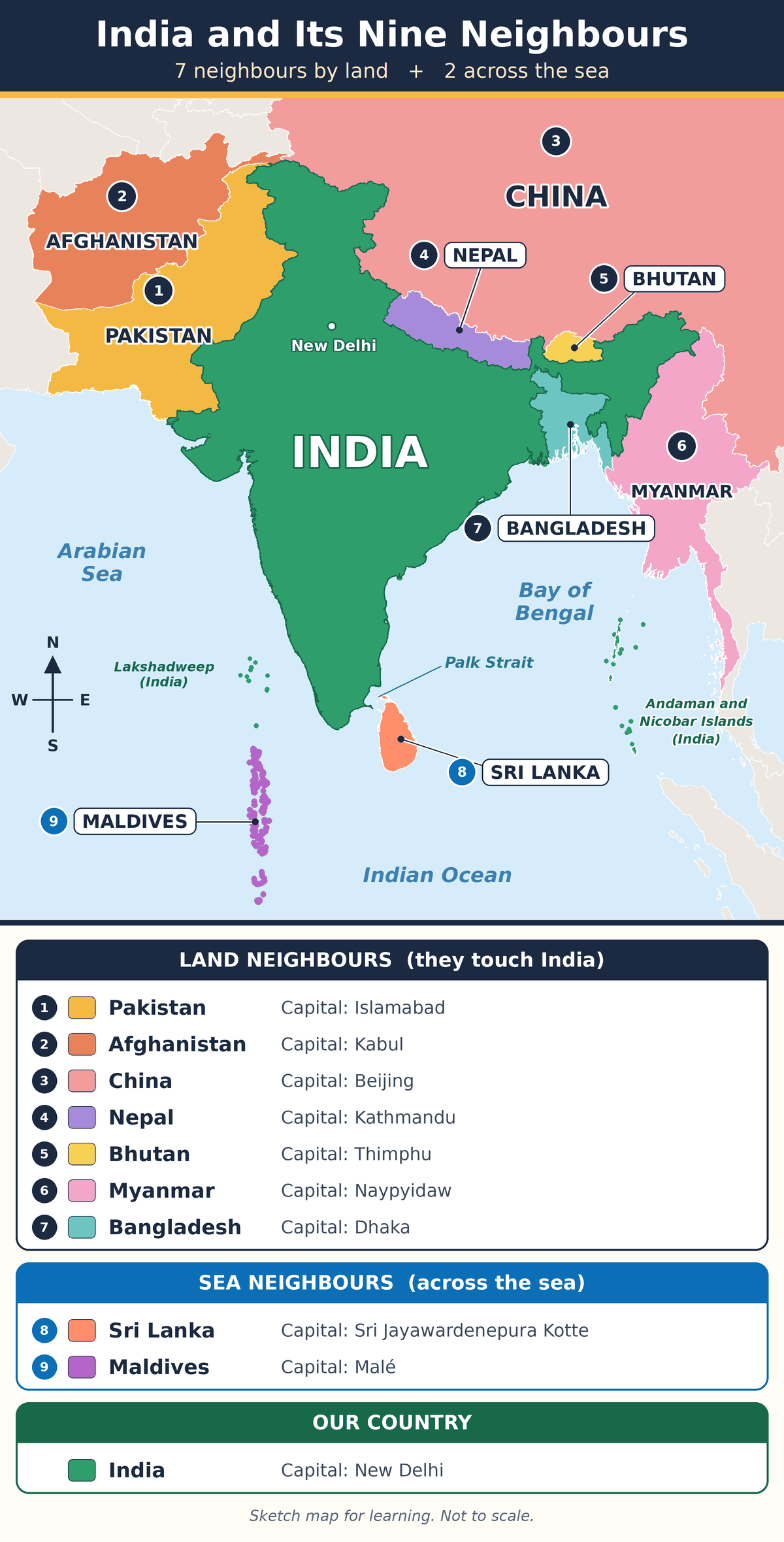
Map of India and its nine neighbours. Pakistan, Afghanistan, China, Nepal, Bhutan, Myanmar and Bangladesh touch India by land. Sri Lanka and the Maldives lie across the sea.

Numbers 1 to 7 go round India’s border, starting from the west. Numbers 8 and 9 are the sea neighbours.

📱 Pinch the picture to zoom in and read the names.

The nine neighbours at a glance

Country and its direction from India Capital, main language and money
🇵🇰 Pakistan
north-west
Capital: Islamabad
Language: Urdu, English
Money: Pakistani rupee
🇦🇫 Afghanistan
far north-west
Capital: Kabul
Language: Dari, Pashto
Money: Afghani
🇨🇳 China
north and north-east
Capital: Beijing
Language: Mandarin Chinese
Money: Renminbi (counted in yuan)
🇳🇵 Nepal
north
Capital: Kathmandu
Language: Nepali
Money: Nepalese rupee
🇧🇹 Bhutan
north-east
Capital: Thimphu
Language: Dzongkha
Money: Ngultrum
🇧🇩 Bangladesh
east
Capital: Dhaka
Language: Bangla (Bengali)
Money: Taka
🇲🇲 Myanmar
east
Capital: Naypyidaw
Language: Burmese
Money: Kyat
🇱🇰 Sri Lanka
south, across the sea
Capital: Sri Jayawardenepura Kotte
Language: Sinhala, Tamil
Money: Sri Lankan rupee
🇲🇻 Maldives
south-west, across the sea
Capital: Malé
Language: Dhivehi
Money: Rufiyaa

India’s own capital is New Delhi and its money is the Indian rupee.

🧠 Memory tricks

  • Seven land neighbours, going round from the west: Polite Aunties Carry Nice Big Mango Baskets = Pakistan, Afghanistan, China, Nepal, Bhutan, Myanmar, Bangladesh.
  • Two sea neighbours: Sea Mates = Sri Lanka, Maldives.

❓ Eight neighbours or nine?

Some school books count only eight neighbours and leave out the Maldives. If your textbook says eight, write eight in your school exam. Remember the Maldives as the ninth neighbour across the sea.

Why should we learn about our neighbours?

Mountains, rivers, seas and rain clouds do not stop at a border. India shares all of these with the countries around it. People have also travelled, traded and shared ideas across these borders for thousands of years. When we know our neighbours, we understand our own land better, and countries can live as friends.

📖 Word Box

Word Meaning in simple words
Neighbouring country A country that lies next to another country, by land or across a narrow sea.
Border The line where one country ends and the next one begins.
Subcontinent A very large piece of land that is part of a continent but stands apart from the rest of it.
Peninsula Land that has water on three sides.
Island Land that has water on all sides.
Maritime neighbour A neighbour across the sea, with no land border.
Capital The city where a country’s government works.
Currency The money used in a country.

📌 Remember This

  • India has 9 neighbours: 7 by land and 2 across the sea.
  • India is a peninsula. It has water on three sides.
  • The Himalayas stand in the north of India.

🎉 Fun Fact

India’s land border is about 15,107 km long. If you walked 30 km every single day, you would need about 504 days to walk along all of it. That is more than a year!

🏠 Try at Home: A paper map with a real sea

  1. Draw a big outline of India on an old newspaper and cut it out.
  2. Write the names of the seven land neighbours on seven small chits of paper.
  3. Keep each chit in its correct place around your paper India.
  4. Write “Sri Lanka” and “Maldives” on two bottle caps. Float them in a plate of water kept below your map. The water is the sea!

Ask an adult to help with the scissors, and to check your map with the picture above.

⚠️ Common Mistakes

Students often say The correct fact
❌ “India has seven neighbours.” ✅ Seven is the number of land neighbours. With Sri Lanka and the Maldives, the total is nine.
❌ “Sri Lanka shares a land border with India.” ✅ Sri Lanka is an island. The sea lies between the two countries.
❌ “Colombo is the capital of Sri Lanka.” ✅ The official capital is Sri Jayawardenepura Kotte. Colombo is the largest city.

🏔️ Topic 2: Neighbours in the West and the North

Five neighbours lie to the west and north of India. Each one is joined to India by a link from nature and a link from the past.

🇵🇰 Pakistan
North-west of India • Capital: Islamabad

Border: Runs along Gujarat, Rajasthan, Punjab, Jammu and Kashmir, and Ladakh.

Link from nature: The Indus river begins in Tibet, crosses Ladakh and flows through Pakistan to the Arabian Sea. Its five big tributaries are the Jhelum, Chenab, Ravi, Beas and Sutlej. The Thar Desert begins in Rajasthan and carries on into Pakistan.

Link from the past: India and Pakistan were one country until 1947. When British rule ended, the land was divided into two countries. This is called the Partition.

Did you know? About 4,500 years ago, people of the Indus Valley Civilisation built well-planned cities. Harappa and Mohenjo-daro are now in Pakistan. Lothal and Dholavira are in India.

🇦🇫 Afghanistan
Far north-west of India • Capital: Kabul

Border: A very short border of about 106 km, high in the mountains at the northern edge of Ladakh. It is shown on India’s official map and is India’s shortest land border.

Link from nature: The Hindu Kush mountains of Afghanistan join the Karakoram and the Himalayas. Together they make one long mountain belt.

Link from the past: Long ago, the Buddha’s teachings travelled from India to Afghanistan. Giant statues of the Buddha were once carved into the cliffs at Bamiyan.

Did you know? Afghan traders brought almonds and raisins to Indian cities. Rabindranath Tagore’s story “Kabuliwala” is about a fruit seller from Kabul. Afghanistan is landlocked: it has no sea coast.

🇨🇳 China
North and north-east of India • Capital: Beijing

Border: Runs along Ladakh, Himachal Pradesh, Uttarakhand, Sikkim and Arunachal Pradesh.

Size: China is the only neighbour bigger than India. It is about three times India’s size.

Link from nature: The Himalayas stand between India and China like a giant wall. A river called the Tsangpo begins in Tibet, enters Arunachal Pradesh and becomes the Brahmaputra in Assam.

Link from the past: Chinese monks came to India to study Buddhism. Fa Hien came about 1,600 years ago. Hiuen Tsang came about 1,400 years ago and studied at Nalanda. Silk and tea came from China. Spices and cotton went from India.

🇳🇵 Nepal
North of India • Capital: Kathmandu

Border: Runs along Uttarakhand, Uttar Pradesh, Bihar, West Bengal and Sikkim. Nepal is landlocked.

Link from nature: India and Nepal share the Himalayas. Mount Everest (8,848.86 m), the highest peak in the world, stands on Nepal’s border with China. Kangchenjunga (8,586 m), the third-highest peak, stands partly in Nepal and partly in Sikkim. Rivers such as the Kosi and the Gandak flow from Nepal into India and join the Ganga.

Link from the past: Gautama Buddha was born at Lumbini, which is in Nepal today. He taught mostly in places that are now in Bihar and Uttar Pradesh, such as Bodh Gaya and Sarnath.

Did you know? Gorkha soldiers from Nepal have served in the Indian Army for many years.

🇧🇹 Bhutan
North-east of India • Capital: Thimphu

Border: Runs along Sikkim, West Bengal, Assam and Arunachal Pradesh. Bhutan is landlocked.

Link from nature: Bhutan sits in the eastern Himalayas. The Manas river flows through Bhutan, enters Assam and joins the Brahmaputra. Forests on both sides protect tigers and elephants.

Link from the past: About 1,300 years ago, a Buddhist teacher from India called Padmasambhava went to Bhutan. People there call him Guru Rinpoche.

Did you know? Bhutan is called the “Land of the Thunder Dragon”. One Bhutanese ngultrum has the same value as one Indian rupee.

📖 Word Box

Word Meaning in simple words
Landlocked Having land on all sides and no sea coast.
Tributary A smaller river that flows into a bigger river.
Civilisation A large group of people living in well-planned cities, with their own writing, trade and rules.
Partition The division of British India into India and Pakistan in 1947.
Monk A person who gives his life to prayer and study of a religion.
Peak The pointed top of a mountain.

📌 Remember This

  • China is the only neighbour bigger than India.
  • Afghanistan, Nepal and Bhutan are landlocked. Trick: Always No Beach.
  • The Buddha was born at Lumbini in Nepal.
  • Two capitals start with K: Kabul for the Kabuliwala, Kathmandu for the mountains.

🎉 Fun Fact

Nepal’s flag is made of two triangles, one above the other. It is the only national flag in the world that does not have four sides.

🏠 Try at Home: Make Nepal’s flag

  1. Take a sheet of red paper, or colour a white sheet red.
  2. Cut out two triangles. Make the lower one a little bigger.
  3. Stick them one above the other on a blue sheet, so that a thin blue border shows.
  4. Draw a white moon in the top triangle and a white sun in the lower one.

Ask an adult to help you with the scissors.

⚠️ Common Mistakes

Students often say The correct fact
❌ “Mount Everest is in India.” ✅ Mount Everest is on the border of Nepal and China. Kangchenjunga is the peak on the border of India and Nepal.
❌ “The Buddha was born in Bodh Gaya.” ✅ He was born at Lumbini in Nepal. Bodh Gaya in Bihar is where he gained enlightenment.
❌ “China’s money is only called the yuan.” ✅ The money is the renminbi. The yuan is the unit used for counting it, just as we count in rupees.

🌊 Topic 3: Neighbours in the East and Across the Sea

Two neighbours lie to the east of India. Two more are islands in the sea.

🇧🇩 Bangladesh
East of India • Capital: Dhaka

Border: Runs along West Bengal, Assam, Meghalaya, Tripura and Mizoram. At about 4,097 km, it is India’s longest land border. India lies on three sides of Bangladesh.

Link from nature: The Ganga and the Brahmaputra flow from India into Bangladesh. There the Ganga is called the Padma and the Brahmaputra is called the Jamuna. Before reaching the sea they make the world’s largest delta. The Sundarbans, the largest mangrove forest in the world, is shared by West Bengal and Bangladesh. The Royal Bengal tiger lives there.

Link from the past: This land was part of British India. In 1947 it became the eastern part of Pakistan. In 1971 it became the independent country of Bangladesh.

Did you know? Rabindranath Tagore wrote the national anthems of both countries: “Jana Gana Mana” for India and “Amar Sonar Bangla” for Bangladesh. Kazi Nazrul Islam, the national poet of Bangladesh, was born in what is now West Bengal.

🇲🇲 Myanmar
East of India’s north-eastern states • Capital: Naypyidaw

Border: Runs along Arunachal Pradesh, Nagaland, Manipur and Mizoram. Myanmar was earlier called Burma.

Link from nature: The border passes through green, forest-covered hills and narrow valleys. A long highway is being built from Moreh in Manipur, through Myanmar, to Thailand.

Link from the past: Traders and monks carried the Buddha’s teachings from India to Myanmar. The golden Shwedagon Pagoda in Yangon is a famous Buddhist shrine. Burma was governed as a part of British India until 1937.

Did you know? The British sent the freedom fighter Bal Gangadhar Tilak to a jail in Mandalay. After the revolt of 1857, they sent the last Mughal emperor, Bahadur Shah Zafar, to Rangoon, which is now called Yangon.

🇱🇰 Sri Lanka
South of India, across the sea • Capital: Sri Jayawardenepura Kotte

Where: An island just off the southern tip of India. On the map it looks like a teardrop below Tamil Nadu. It was earlier called Ceylon.

Link from nature: A narrow strip of sea called the Palk Strait lies between Tamil Nadu and Sri Lanka. Like the south-east coast of India, Sri Lanka gets rain in two seasons.

Link from the past: Emperor Ashoka sent his son Mahinda and his daughter Sanghamitra to Sri Lanka to share the Buddha’s teachings. Sanghamitra carried a young branch of the Bodhi tree. A temple in Kandy is believed to keep a tooth of the Buddha.

Did you know? Tamil is spoken in Tamil Nadu and also by many people in Sri Lanka. Colombo is Sri Lanka’s largest city, but it is not the official capital.

🇲🇻 Maldives
South-west of India, across the sea • Capital: Malé

Where: A chain of about 1,200 tiny coral islands in the Indian Ocean. It is the smallest country in Asia.

Link from nature: The islands are made by corals, just like India’s Lakshadweep islands, which lie just to their north. Most of the land is only a metre or two above the sea, so rising sea levels are a big worry.

Link from the past: Long ago, small cowrie shells from the Maldives were used as coins in many parts of India. Sailors and traders have crossed between the Indian coast and these islands for hundreds of years.

📖 Word Box

Word Meaning in simple words
Delta Flat land shaped like a triangle, made of mud that a river drops where it meets the sea.
Mangrove A tree that can grow in salty, muddy water near the coast.
Strait A narrow strip of sea between two pieces of land.
Coral island An island built up over a long time from the hard skeletons of tiny sea animals called corals.
Relic An object kept and respected because it belonged to a holy person or to a time long ago.
Pagoda A tower-shaped Buddhist shrine.
Independent Free to rule itself, not ruled by another country.

📌 Remember This

  • Bangladesh has the longest border with India. Trick: “B for the biggest border, A for a tiny one.”
  • Ganga becomes Padma. Brahmaputra becomes Jamuna.
  • The Palk Strait lies between India and Sri Lanka.
  • The Maldives is the smallest country in Asia.
  • “In Dhaka, you pay in taka.”

🎉 Fun Fact

One poet, two anthems! Rabindranath Tagore wrote the national anthem of India and the national anthem of Bangladesh.

🏠 Try at Home: Make a tiny delta

  1. Take a steel plate or tray and keep one end a little higher, on a book.
  2. Press a layer of wet soil or sand on the plate.
  3. Slowly pour a glass of water at the higher end.
  4. Watch the water cut one path, then split into many small paths near the lower end. That is how a delta is made.

Do this in a balcony or near a sink, and wash your hands afterwards.

⚠️ Common Mistakes

Students often say The correct fact
❌ “Yangon is the capital of Myanmar.” ✅ The capital is Naypyidaw. Yangon is the largest city and was the capital earlier.
❌ “Bangladesh was formed in 1947.” ✅ In 1947 it became the eastern part of Pakistan. It became Bangladesh in 1971.
❌ “Bangla and Bengali are different languages.” ✅ They are two names for the same language.

🤝 Topic 4: What We Share, and Who Is Big or Small

Five big links join India to its neighbours: mountains, rivers, Buddhism, history and money.

1. Mountains

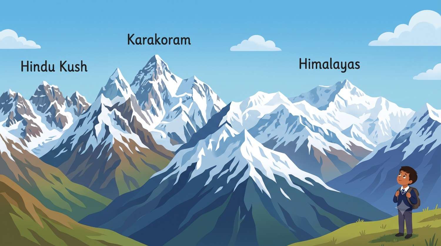
One long belt of mountains runs across the north. It is called the Hindu Kush in Afghanistan, the Karakoram further east and the Himalayas after that. Afghanistan, Pakistan, India, China, Nepal and Bhutan all share this belt.

2. Rivers
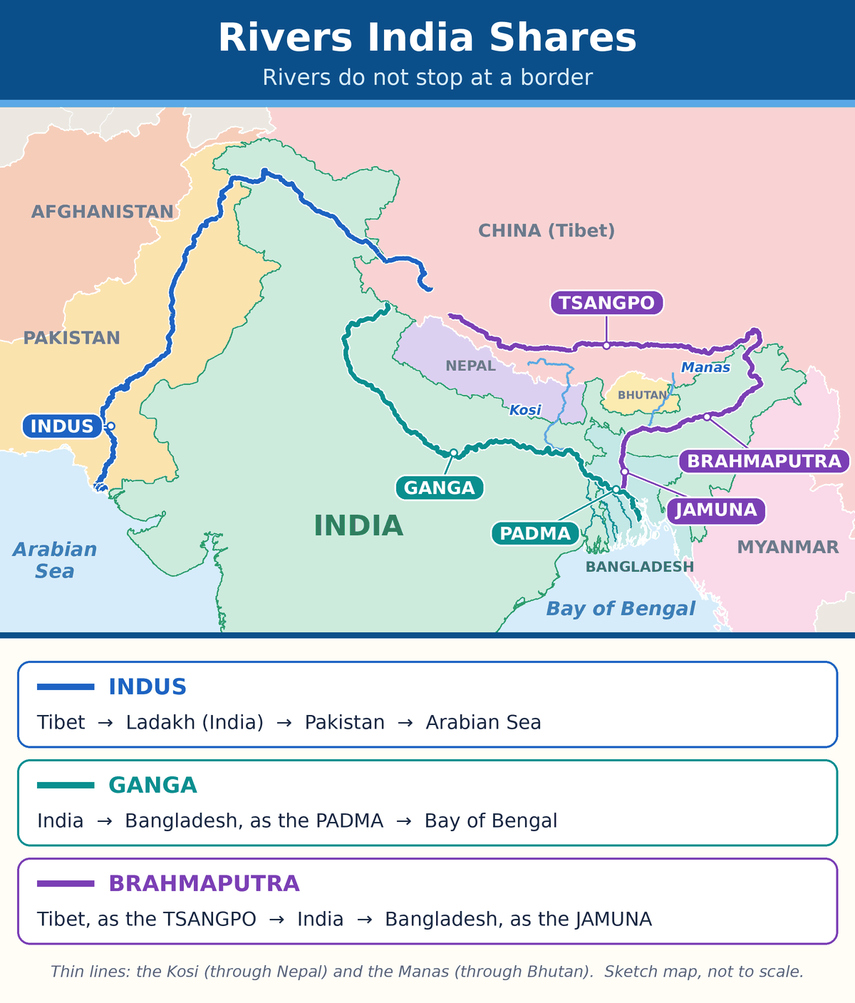
Map of three rivers that India shares. The Indus flows from Tibet through Ladakh and Pakistan to the Arabian Sea. The Ganga flows through India into Bangladesh, where it is called the Padma. The Tsangpo from Tibet becomes the Brahmaputra in India and the Jamuna in Bangladesh.

Follow each coloured line from where the river begins to the sea.

📱 Pinch the picture to zoom in and follow each river.

River and where it begins Its journey
Indus
begins in Tibet (China)
Ladakh in India, then Pakistan, then the Arabian Sea.
Brahmaputra
begins in Tibet (China)
Called the Tsangpo in Tibet. Flows through Arunachal Pradesh and Assam. Called the Jamuna in Bangladesh.
Ganga
begins in Uttarakhand (India)
The northern plains of India, then Bangladesh, where it is called the Padma.
Kosi
begins in the Himalayas of Nepal and Tibet
Nepal, then Bihar in India, where it joins the Ganga.
Manas
begins in Bhutan
Bhutan, then Assam in India, where it joins the Brahmaputra.

Trick for the three names of one river: Tiny Becomes Jumbo = Tsangpo, Brahmaputra, Jamuna.

3. Buddhism

Buddhism began in India about 2,500 years ago and travelled to almost every neighbour.

Country Its Buddhist link with India
Nepal The Buddha was born at Lumbini.
Sri Lanka Ashoka’s children Mahinda and Sanghamitra took the teachings there.
Afghanistan Giant Buddha statues were carved at Bamiyan.
China The monks Fa Hien and Hiuen Tsang came to India to study.
Bhutan The Indian teacher Padmasambhava (Guru Rinpoche) took the teachings there.
Myanmar Monks and traders carried the teachings there. The Shwedagon Pagoda is in Yangon.

4. History: a timeline

When What happened
Before 1937 Present-day India, Pakistan, Bangladesh and Myanmar were governed together as British India.
1937 Burma (Myanmar) was separated from British India.
1947 British rule ended. India and Pakistan became two independent countries.
1948 Burma (Myanmar) and Ceylon (Sri Lanka) became independent.
1971 The eastern part of Pakistan became the new country of Bangladesh.

Nepal, Bhutan and Afghanistan were not ruled directly by the British.

5. Money

Four countries call their money the rupee: Pakistan, India, Nepal and Sri Lanka. Trick: PINS. Each country prints its own notes, and each rupee has a different value. The Maldivian word rufiyaa comes from the same old word as rupee.

🔗 Cause and effect

Cause (why) Effect (what happens)
Nepal and Bhutan have no sea coast. Their goods travel through India to reach a seaport.
The islands of the Maldives are only a metre or two above the sea. Rising sea levels are a big worry for the people.
Rivers flow from one country into the next. Countries must share the water and warn each other about floods.
Monks and traders travelled by road and by sea. Buddhism spread from India to its neighbours.

Who is big, who is small?

The table goes from the largest country to the smallest.

Country Size next to India Border with India
China
has a sea coast
About 3 times bigger 3,488 km
Pakistan
has a sea coast
About one-fourth of India 3,323 km
Myanmar
has a sea coast
About one-fifth of India 1,643 km
Afghanistan
landlocked
About one-fifth of India 106 km
Bangladesh
has a sea coast
About 22 times smaller 4,097 km
Nepal
landlocked
About 22 times smaller 1,751 km
Sri Lanka
an island
About 50 times smaller None. It is a sea neighbour.
Bhutan
landlocked
About 85 times smaller 699 km
Maldives
a group of islands
More than 10,000 times smaller None. It is a sea neighbour.

India’s total land border is about 15,107 km, shared with seven countries.

✏️ Worked example: reading the table

Question: Which border is longer, the one with China or the one with Pakistan? By how much?

Step 1. Find both numbers in the table. China: 3,488 km. Pakistan: 3,323 km.

Step 2. Compare them. 3,488 is more than 3,323.

Step 3. Subtract. 3,488 − 3,323 = 165.

Answer: The border with China is longer by 165 km.

We are alike in many ways

Neighbour A popular food Something like it in India
Nepal and Bhutan Momos Momos in Sikkim and Ladakh
Bangladesh Hilsa fish with rice Hilsa fish in West Bengal
Pakistan Biryani Biryani in Hyderabad and Lucknow
Sri Lanka Hoppers Appam in Kerala
Afghanistan Kabuli pulao Pulao across north India

📖 Word Box

Word Meaning in simple words
Seaport A place on the coast where ships load and unload goods.
Sea level The height of the top of the sea.
Timeline A list of events in the order in which they happened.
Shrine A holy place where people go to pray.

📌 Remember This

  • Biggest neighbour: China. Smallest neighbour: Maldives. Smallest land neighbour: Bhutan.
  • Longest border: Bangladesh. Shortest border: Afghanistan.
  • Rupee countries: Pakistan, India, Nepal, Sri Lanka (PINS).
  • 1947: India and Pakistan. 1971: Bangladesh.

🎉 Fun Fact

One Bhutanese ngultrum has exactly the same value as one Indian rupee. So 10 ngultrum and 10 rupees are worth the same!

🏠 Try at Home: A border bar chart

  1. Take a ruler, a pencil and seven strips of old paper.
  2. Use this rule: 1 cm for every 500 km.
  3. Cut the strips: Bangladesh 8.2 cm, China 7.0 cm, Pakistan 6.6 cm, Nepal 3.5 cm, Myanmar 3.3 cm, Bhutan 1.4 cm and Afghanistan 0.2 cm.
  4. Stick them side by side in your notebook and write the country name under each strip.

Which strip is the tallest? Which is so small that you can hardly cut it?

⚠️ Common Mistakes

Students often say The correct fact
❌ “China has the longest border with India.” ✅ Bangladesh has the longest border with India. China is the biggest neighbour by size.
❌ “All rupees are the same.” ✅ India, Pakistan, Nepal and Sri Lanka each have their own rupee with a different value.
❌ “The Brahmaputra begins in India.” ✅ It begins in Tibet (China), where it is called the Tsangpo.
🖼️ Section C: Picture Cards

Eight picture cards for quick revision. Read the yellow Key point on each card twice.
Picture Card 1: India and Its Nine Neighbours
Map of India in green with its seven land neighbours and two sea neighbours in other colours.

📱 Pinch the picture to zoom in.

This map shows India in green and its nine neighbours in other colours.

Key point: Seven neighbours touch India by land. Two neighbours, Sri Lanka and the Maldives, lie across the sea.

Start at number 1 in the west and go round the border to number 7.

Picture Card 2: One Long Mountain Belt
A long chain of snowy mountains labelled Hindu Kush, Karakoram and Himalayas from left to right.

One long belt of mountains runs across the north of India.

Key point: It is called the Hindu Kush in Afghanistan, the Karakoram further east and the Himalayas after that.

Six countries share it: Afghanistan, Pakistan, India, China, Nepal and Bhutan.

Picture Card 3: Rivers Do Not Stop at a Border
Map showing the Indus, the Ganga and the Brahmaputra flowing from one country into the next.

📱 Pinch the picture to zoom in.

Three big rivers flow through India and also through a neighbour.

Key point: One river has three names: Tsangpo in Tibet, Brahmaputra in India and Jamuna in Bangladesh.

The Ganga is called the Padma in Bangladesh. The Indus flows on into Pakistan.

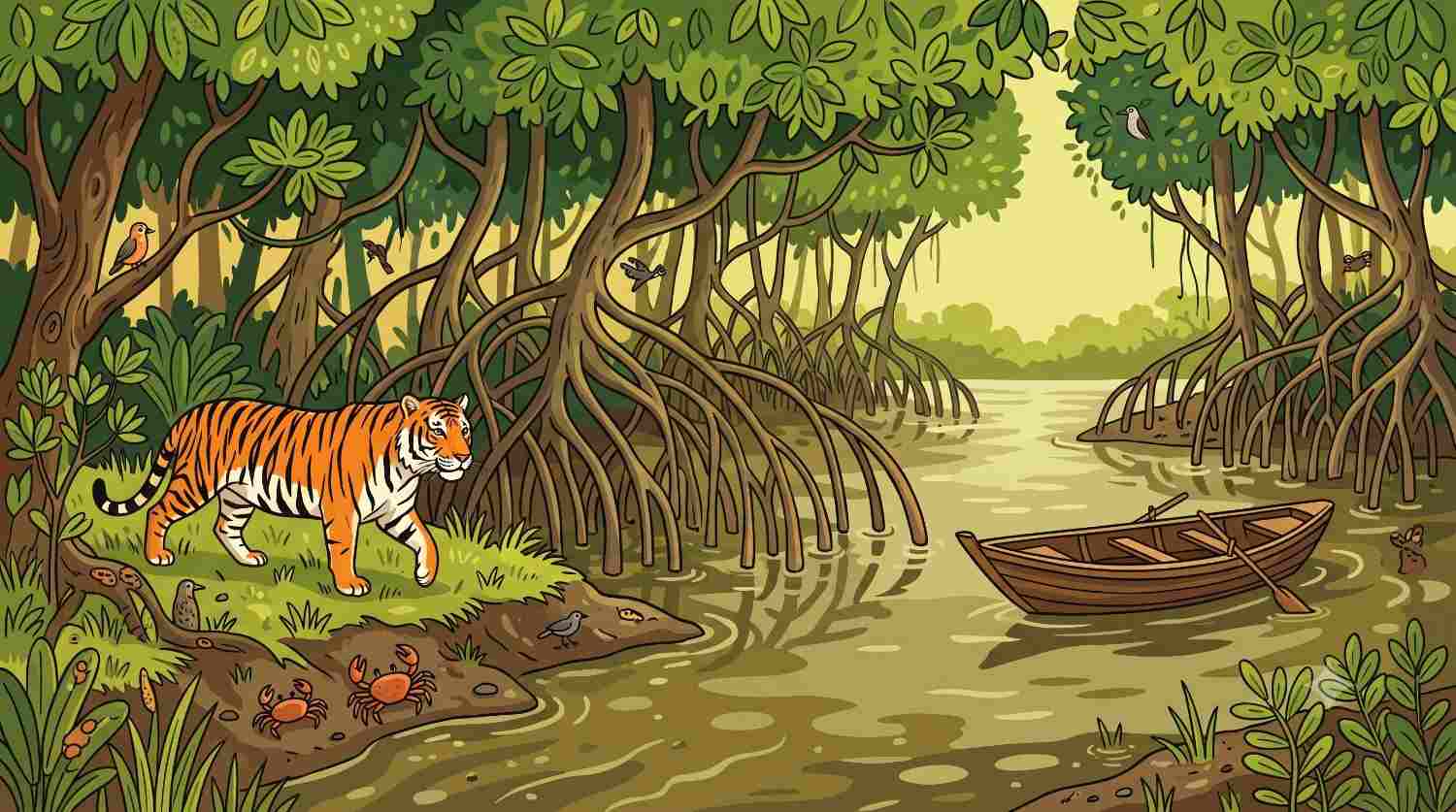
Picture Card 4: The Sundarbans
A Royal Bengal tiger on the muddy bank of a mangrove forest, with a small boat on the river.

The Sundarbans is the largest mangrove forest in the world.

Key point: It is shared by West Bengal in India and by Bangladesh. The Royal Bengal tiger lives there.

Mangrove trees protect the coast from storms and high waves.

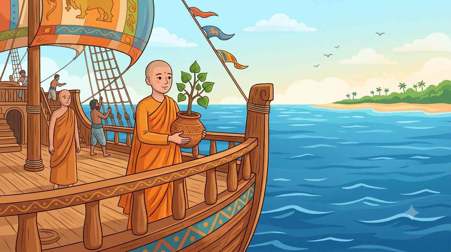
Picture Card 5: The Buddha’s Teachings Travel
Sanghamitra on a wooden sailing ship, carrying a Bodhi tree sapling to Sri Lanka.

Buddhism began in India about 2,500 years ago.

Key point: The Buddha was born at Lumbini in Nepal. Monks, traders and kings such as Ashoka carried his teachings to the neighbouring countries.

Ashoka’s children, Mahinda and Sanghamitra, took the teachings to Sri Lanka.

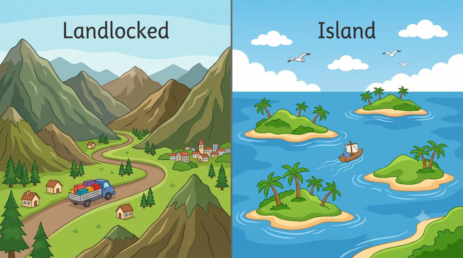
Picture Card 6: No Beach and All Beach
Left: a truck on a mountain road in a landlocked country. Right: small islands in the sea.

A landlocked country has land on all sides. An island has water on all sides.

Key point: Afghanistan, Nepal and Bhutan are landlocked. Sri Lanka and the Maldives are islands.

A landlocked country sends its goods through another country to reach a seaport.

Picture Card 7: Flags at a Glance
Flag Country Easy way to spot it
🇮🇳 India The navy-blue wheel (Ashoka Chakra)
🇵🇰 Pakistan Crescent and star on green
🇦🇫 Afghanistan Black, red and green stripes (in most textbooks)
🇨🇳 China Five yellow stars on red
🇳🇵 Nepal Two triangles, one above the other
🇧🇹 Bhutan The dragon
🇧🇩 Bangladesh Red circle on green
🇲🇲 Myanmar Big white star
🇱🇰 Sri Lanka The lion with a sword
🇲🇻 Maldives White crescent in a green box

Every country has its own flag. The flag shows that the country is independent.

Key point: Nepal’s flag is the only national flag in the world that does not have four sides.

India’s flag has three bands: saffron, white and green. A navy-blue wheel with 24 spokes sits in the centre.

Note for the teacher: AI picture tools often draw flags wrongly, so no image prompt is given for this card. Keep this table as it is, or upload real flag pictures. On some computers the small flags may show as two letters. They show correctly on most phones.
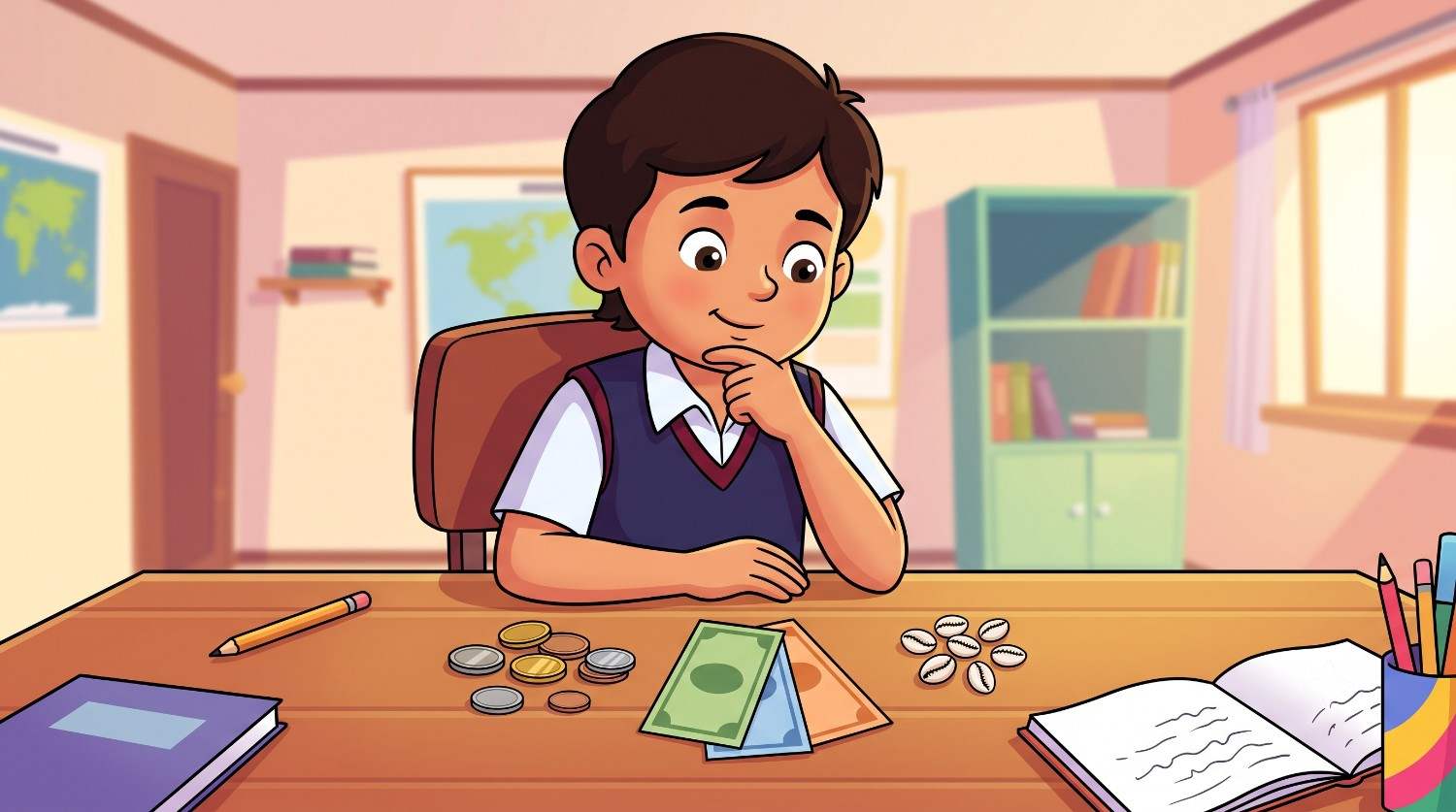
Picture Card 8: Money of the Neighbours
A child looking at coins, banknotes and small white cowrie shells on a desk.

Every country has its own money. It is called its currency.

Key point: Four countries call their money the rupee: Pakistan, India, Nepal and Sri Lanka (PINS). Each rupee has a different value.

Long ago, cowrie shells from the Maldives were used as coins in many parts of India.

🃏 Section D: Flash Cards

Read the question. Say your answer aloud. Then tap the card to flip it and check.

Card 1: How many neighbours does India have?
💡 Nine. Seven touch India by land. Two, Sri Lanka and the Maldives, lie across the sea.
Card 2: What is a peninsula?
💡 Land with water on three sides. India is a peninsula.
Card 3: Name the seven land neighbours of India.
💡 Pakistan, Afghanistan, China, Nepal, Bhutan, Myanmar and Bangladesh. Trick: Polite Aunties Carry Nice Big Mango Baskets.
Card 4: What does “landlocked” mean? Give examples.
💡 Having land on all sides and no sea coast. Afghanistan, Nepal and Bhutan are landlocked.
Card 5: Which neighbour is bigger than India?
💡 Only China. It is about three times India’s size.
Card 6: True or false: China has the longest border with India.
💡 False. Bangladesh has the longest border, about 4,097 km. China is the biggest neighbour by size.
Card 7: Which neighbour has the shortest border with India?
💡 Afghanistan. The border is about 106 km long, as shown on India’s official map.
Card 8: What is the capital of Sri Lanka?
💡 Sri Jayawardenepura Kotte. Colombo, right next to it, is the largest city.
Card 9: What is the capital of Myanmar?
💡 Naypyidaw. Yangon is the largest city and was the capital earlier.
Card 10: Which country uses the ngultrum?
💡 Bhutan. One ngultrum has the same value as one Indian rupee.
Card 11: One river has three names. What are they?
💡 Tsangpo in Tibet, Brahmaputra in India and Jamuna in Bangladesh. Trick: Tiny Becomes Jumbo.
Card 12: What is the Ganga called in Bangladesh?
💡 The Padma.
Card 13: Where was Gautama Buddha born?
💡 At Lumbini, which is in Nepal today.
Card 14: Why is the Sundarbans important?
💡 It is the world’s largest mangrove forest and the home of the Royal Bengal tiger. India and Bangladesh share it. Its trees protect the coast from storms.
Card 15: True or false: Sri Lanka touches India by land.
💡 False. Sri Lanka is an island. The Palk Strait lies between India and Sri Lanka.
Card 16: When did Bangladesh become an independent country?
💡 In 1971. From 1947 to 1971 it was the eastern part of Pakistan.
Card 17: Why is a rising sea a big worry for the Maldives?
💡 Most of its land is only a metre or two above the sea. Rising water can cover the islands.
Card 18: Which four countries call their money the rupee?
💡 Pakistan, India, Nepal and Sri Lanka. Trick: PINS. Each rupee has a different value.
Card 19: Which national flag does not have four sides?
💡 Nepal’s flag. It is made of two triangles, one above the other.
Card 20: Why do Nepal and Bhutan send goods through India?
💡 They are landlocked. They have no sea coast and no seaport, so their goods travel through India to reach one.
🧠 Section E: Mind Map
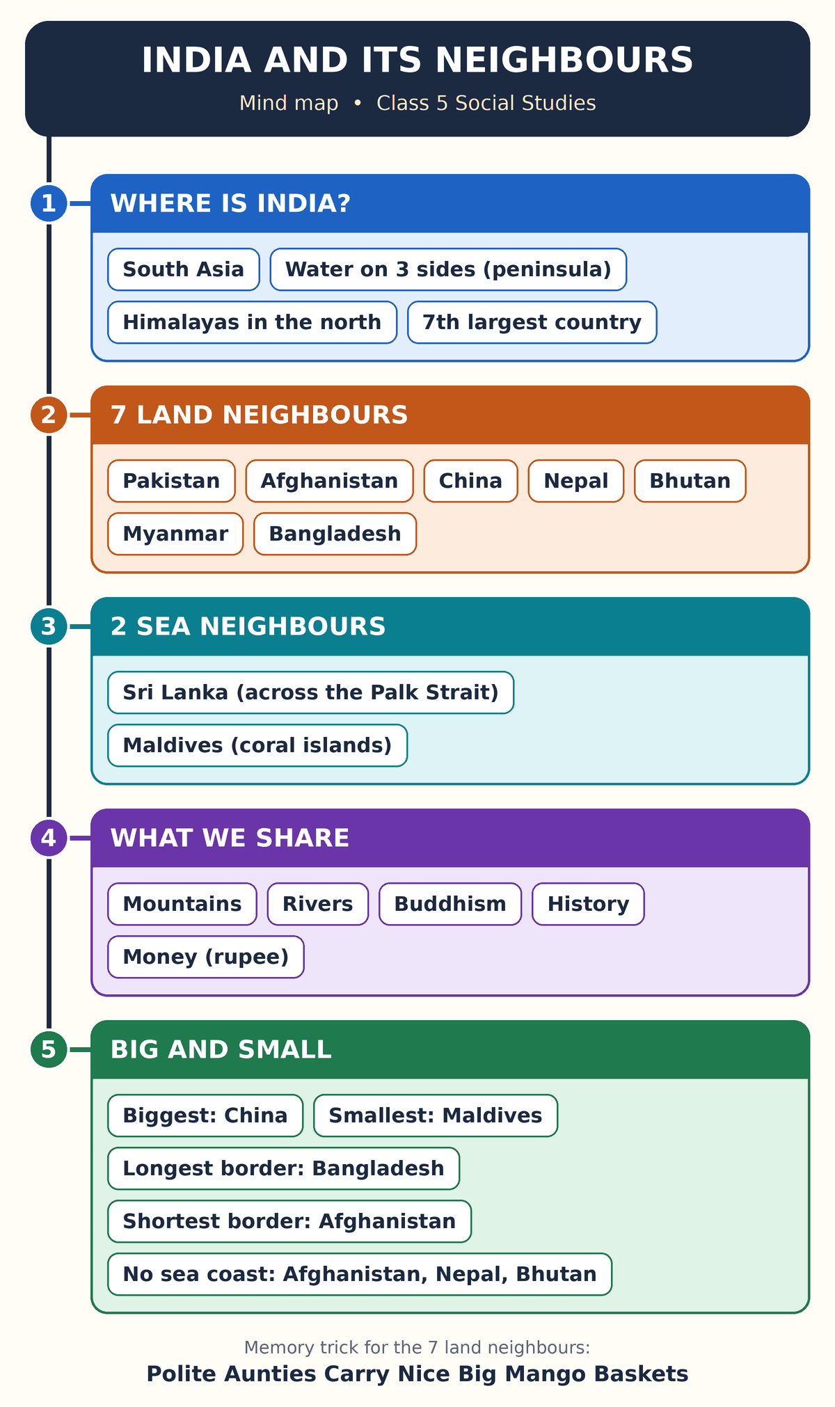
Mind map of the chapter with five branches: Where is India, Seven land neighbours, Two sea neighbours, What we share, and Big and small.

📱 Pinch the picture to zoom in.

📝 The same mind map in words

INDIA AND ITS NEIGHBOURS
1. Where is India?
South AsiaWater on three sides (a peninsula)Himalayas in the northSeventh-largest country
2. Seven land neighbours
PakistanAfghanistanChinaNepalBhutanMyanmarBangladesh
3. Two sea neighbours
Sri Lanka, across the Palk StraitMaldives, a chain of coral islands
4. What we share
Mountains: Hindu Kush, Karakoram, HimalayasRivers: Indus, Ganga, BrahmaputraBuddhismHistory: 1947 and 1971Money: the rupee (PINS)
5. Big and small
Biggest: ChinaSmallest: MaldivesLongest border: BangladeshShortest border: AfghanistanNo sea coast: Afghanistan, Nepal, Bhutan

📋 Outline

  • 1. Where is India?
    • South Asia
    • Water on three sides (a peninsula)
    • Himalayas in the north
    • Seventh-largest country
  • 2. Seven land neighbours
    • Pakistan
    • Afghanistan
    • China
    • Nepal
    • Bhutan
    • Myanmar
    • Bangladesh
  • 3. Two sea neighbours
    • Sri Lanka, across the Palk Strait
    • Maldives, a chain of coral islands
  • 4. What we share
    • Mountains: Hindu Kush, Karakoram, Himalayas
    • Rivers: Indus, Ganga, Brahmaputra
    • Buddhism
    • History: 1947 and 1971
    • Money: the rupee (PINS)
  • 5. Big and small
    • Biggest: China
    • Smallest: Maldives
    • Longest border: Bangladesh
    • Shortest border: Afghanistan
    • No sea coast: Afghanistan, Nepal, Bhutan
✏️ Section F: Short and Long Answers

Try to write your own answer first. Then tap to see the model answer.

✏️ 10 Short Questions (about 30 to 50 words each)

Short 1. How many neighbours does India have? Name the seven land neighbours. (tap for the model answer)

India has nine neighbours: seven by land and two across the sea. The land neighbours are Pakistan, Afghanistan, China, Nepal, Bhutan, Myanmar and Bangladesh. Sri Lanka and the Maldives are the sea neighbours.

Short 2. Why is India called a peninsula? (tap for the model answer)

A peninsula is land that has water on three sides. India has the Arabian Sea in the west, the Bay of Bengal in the east and the Indian Ocean in the south, so India is called a peninsula.

Short 3. What is a landlocked country? Name the three landlocked neighbours of India. (tap for the model answer)

A landlocked country has land on all sides and no sea coast. Afghanistan, Nepal and Bhutan are landlocked neighbours of India. The trick to remember them is “Always No Beach”.

Short 4. Which neighbour is bigger than India? How big is it? (tap for the model answer)

China is the only neighbour that is bigger than India. It is about three times the size of India. The Himalayas stand between India and China like a giant wall.

Short 5. Which neighbour has the longest border and which has the shortest land border with India? (tap for the model answer)

Bangladesh has the longest land border with India, about 4,097 km. Afghanistan has the shortest, only about 106 km, high in the mountains at the northern edge of Ladakh.

Short 6. What was the Partition? When did it happen? (tap for the model answer)

Partition means the division of British India into two countries, India and Pakistan. It happened in 1947 when British rule ended. India and Pakistan were one country before that.

Short 7. Name the river Tsangpo and tell where it becomes the Brahmaputra. (tap for the model answer)

The Tsangpo begins in Tibet in China. It enters India in Arunachal Pradesh. In Assam it becomes the Brahmaputra, which then flows on into Bangladesh.

Short 8. Why is the Maldives called a sea neighbour of India? What is special about it? (tap for the model answer)

The Maldives lies across the sea, so it has no land border with India. It is a chain of about 1,200 tiny coral islands and is the smallest country in Asia. Its capital is Malé.

Short 9. What is the Palk Strait? Which two places does it separate? (tap for the model answer)

The Palk Strait is a narrow strip of sea. It lies between Tamil Nadu in India and the island country of Sri Lanka. A strait is a narrow strip of sea between two pieces of land.

Short 10. Why should we learn about our neighbours? (tap for the model answer)

Mountains, rivers, seas and rain clouds do not stop at a border, and India shares them with its neighbours. People have also travelled, traded and shared ideas for thousands of years. Knowing our neighbours helps countries live as friends.

📝 10 Long Questions (about 80 to 120 words each)

Long 1. Describe the location of India. Why is India called a peninsula and a part of the Indian subcontinent? (tap for the model answer)

Introduction: India is in South Asia, on a huge piece of land called the Indian subcontinent. It is the seventh-largest country in the world.

Main points: India has water on three sides: the Arabian Sea in the west, the Bay of Bengal in the east and the Indian Ocean in the south. Land with water on three sides is called a peninsula, so India is a peninsula. In the north stand the Himalayas, the highest mountains in the world. Kanniyakumari in Tamil Nadu is the southern tip of the mainland. A subcontinent is a very large piece of land that is part of a continent but stands apart from the rest of it.

Example: The Himalayas in the north and the seas on the other three sides separate India from the rest of Asia.

Conclusion: India’s position makes it a land of mountains, plains, coasts and seas.

Long 2. Name the nine neighbours of India. Tell which are land neighbours and which are sea neighbours, with their capitals. (tap for the model answer)

Introduction: A neighbouring country is a country that lies next to our country. India has nine neighbours.

Main points: The seven land neighbours are Pakistan (capital Islamabad), Afghanistan (Kabul), China (Beijing), Nepal (Kathmandu), Bhutan (Thimphu), Bangladesh (Dhaka) and Myanmar (Naypyidaw). The two sea neighbours, also called maritime neighbours, are Sri Lanka (Sri Jayawardenepura Kotte) and the Maldives (Malé). The land neighbours touch India’s border, and the sea neighbours lie across the sea.

Example: To remember the land neighbours going round from the west, we can say: Polite Aunties Carry Nice Big Mango Baskets.

Conclusion: Some school books count eight neighbours and leave out the Maldives, so we should write the number given in our own textbook.

Long 3. Describe how India and Pakistan are linked by nature and by history. (tap for the model answer)

Introduction: Pakistan lies to the north-west of India. Its capital is Islamabad.

Main points: The border runs along Gujarat, Rajasthan, Punjab, Jammu and Kashmir, and Ladakh. The Indus river begins in Tibet, crosses Ladakh and flows through Pakistan to the Arabian Sea. Its five big tributaries are the Jhelum, Chenab, Ravi, Beas and Sutlej. The Thar Desert begins in Rajasthan and carries on into Pakistan. India and Pakistan were one country until 1947, when the land was divided at the end of British rule.

Example: About 4,500 years ago, the Indus Valley Civilisation built well-planned cities. Harappa and Mohenjo-daro are now in Pakistan, and Lothal and Dholavira are in India.

Conclusion: Rivers, deserts and history join India and Pakistan very closely.

Long 4. Describe how China is linked with India. In what ways is China different from the other neighbours? (tap for the model answer)

Introduction: China lies to the north and north-east of India. Its capital is Beijing.

Main points: The border runs along Ladakh, Himachal Pradesh, Uttarakhand, Sikkim and Arunachal Pradesh. China is the only neighbour bigger than India, about three times its size. The Himalayas stand between the two countries like a giant wall. The Tsangpo begins in Tibet and becomes the Brahmaputra in Assam. Chinese monks like Fa Hien and Hiuen Tsang came to India to study Buddhism, and Hiuen Tsang studied at Nalanda. Silk and tea came from China, and spices and cotton went from India.

Example: Hiuen Tsang came about 1,400 years ago and studied at Nalanda.

Conclusion: China is the biggest neighbour, and it has shared trade and ideas with India for a very long time.

Long 5. Describe Nepal and Bhutan. How are they linked with India? (tap for the model answer)

Introduction: Nepal lies to the north of India and Bhutan to the north-east. Both are landlocked Himalayan neighbours.

Main points: India and Nepal share the Himalayas. Mount Everest, the highest peak in the world, stands on Nepal’s border with China, and Kangchenjunga stands partly in Nepal and partly in Sikkim. Rivers like the Kosi and the Gandak flow from Nepal into India and join the Ganga. Gautama Buddha was born at Lumbini in Nepal. Bhutan lies in the eastern Himalayas, and the Manas river flows through it into Assam. A Buddhist teacher from India, Padmasambhava, went to Bhutan about 1,300 years ago.

Example: Gorkha soldiers from Nepal have served in the Indian Army for many years. One Bhutanese ngultrum has the same value as one Indian rupee.

Conclusion: Nepal and Bhutan are friendly neighbours linked with India by mountains, rivers and religion.

Long 6. Describe Bangladesh and tell how it is linked with India. (tap for the model answer)

Introduction: Bangladesh lies to the east of India. Its capital is Dhaka, and its language is Bangla.

Main points: Its border with India is about 4,097 km, the longest land border of India, and India lies on three sides of Bangladesh. The Ganga and the Brahmaputra flow from India into Bangladesh, where they are called the Padma and the Jamuna. Before reaching the sea they make the world’s largest delta. The Sundarbans, the largest mangrove forest in the world, is shared by West Bengal and Bangladesh. This land was part of British India, became East Pakistan in 1947 and became independent Bangladesh in 1971.

Example: Rabindranath Tagore wrote the national anthems of both countries: Jana Gana Mana and Amar Sonar Bangla.

Conclusion: Rivers, forests, language and history link India and Bangladesh.

Long 7. Describe Myanmar and its links with India. (tap for the model answer)

Introduction: Myanmar lies to the east of India’s north-eastern states. It was earlier called Burma, and its capital is Naypyidaw.

Main points: The border runs along Arunachal Pradesh, Nagaland, Manipur and Mizoram, through green forest-covered hills and narrow valleys. A long highway is being built from Moreh in Manipur, through Myanmar, to Thailand. Traders and monks carried the Buddha’s teachings from India to Myanmar, and the golden Shwedagon Pagoda in Yangon is a famous Buddhist shrine. Burma was governed as a part of British India until 1937.

Example: The British sent Bal Gangadhar Tilak to a jail in Mandalay, and sent the last Mughal emperor, Bahadur Shah Zafar, to Rangoon, now called Yangon.

Conclusion: Myanmar is India’s gateway to South-East Asia.

Long 8. Describe Sri Lanka and its links with India. (tap for the model answer)

Introduction: Sri Lanka is an island country south of India, across the sea. It was earlier called Ceylon. Its capital is Sri Jayawardenepura Kotte.

Main points: On the map it looks like a teardrop below Tamil Nadu. A narrow strip of sea called the Palk Strait lies between Tamil Nadu and Sri Lanka. Like the south-east coast of India, Sri Lanka gets rain in two seasons. Emperor Ashoka sent his son Mahinda and his daughter Sanghamitra to Sri Lanka to share the Buddha’s teachings. Sanghamitra carried a young branch of the Bodhi tree.

Example: Tamil is spoken in Tamil Nadu and also by many people in Sri Lanka. Colombo is the largest city, but it is not the official capital.

Conclusion: Sri Lanka is a close sea neighbour with old links to India.

Long 9. Describe the Maldives. Why is rising sea level a big worry for it? (tap for the model answer)

Introduction: The Maldives lies to the south-west of India, across the sea, in the Indian Ocean. Its capital is Malé and its money is the rufiyaa.

Main points: It is a chain of about 1,200 tiny coral islands and is the smallest country in Asia. The islands are made by corals, just like India’s Lakshadweep islands, which lie just to their north. Most of the land is only a metre or two above the sea, so if the sea level rises, the islands may be flooded. Long ago, small cowrie shells from the Maldives were used as coins in many parts of India.

Example: Sailors and traders have crossed between the Indian coast and these islands for hundreds of years.

Conclusion: The Maldives is tiny and beautiful, and it needs the world to protect the sea and the climate.

Long 10. Explain how Buddhism, rivers and trade have linked India with its neighbours. (tap for the model answer)

Introduction: India and its neighbours are joined not only by borders but also by nature and by long years of shared history.

Main points: The Buddha’s teachings travelled from India to Afghanistan, Myanmar, Sri Lanka and Bhutan, and Chinese monks like Fa Hien and Hiuen Tsang came to India to study Buddhism. The Indus, the Ganga and the Brahmaputra flow across borders, and the Kosi, the Gandak and the Manas come from Nepal and Bhutan into India. Trade also joined the countries: silk and tea came from China, spices and cotton went from India, and cowrie shells from the Maldives were used as coins.

Example: Emperor Ashoka sent his son Mahinda and his daughter Sanghamitra to Sri Lanka with a branch of the Bodhi tree.

Conclusion: These old links show that India and its neighbours have always depended on each other and can live as friends.

🔍 Section G: Case Studies

Read each short story. Answer the five questions in your notebook. Then tap to check your answers.

There are ten stories. Together they visit all nine neighbours of India.

Case Study 1: Dry Fruits for Diwali

Just before Diwali, Meher went with her Nani to Crawford Market in Mumbai. Nani bought almonds and raisins from an old shop. “These have come all the way from Afghanistan,” said the shopkeeper. “My grandfather bought them from traders who came from Kabul.” Meher looked at the map in her school diary. Afghanistan had no blue sea next to it. It had mountains called the Hindu Kush. “How do the dry fruits reach Mumbai if there is no sea?” she asked. Nani smiled. “They travel a long way by road through other countries first.” That evening, Nani read her the story “Kabuliwala”.

Questions

  1. From which country did the dry fruits come? What is its capital?
  2. Afghanistan has no sea coast. What is such a country called?
  3. Name the mountains of Afghanistan in the story.
  4. Why must goods from Afghanistan travel through other countries first?
  5. Who wrote the story “Kabuliwala”?
👇 Tap to see the answers
  1. They came from Afghanistan. Its capital is Kabul.
  2. It is called a landlocked country.
  3. The Hindu Kush.
  4. Afghanistan has no sea coast and no seaport of its own, so its goods go by road through other countries.
  5. Rabindranath Tagore.
Case Study 2: A Boat Ride in the Sundarbans

Class 5 of a school in Kolkata went on a trip to the Sundarbans. Their boat moved slowly between trees whose roots stood in muddy water. “These are mangrove trees,” said the guide, Shankar Kaka. “This is the largest mangrove forest in the world. One part is in West Bengal. The other part is in Bangladesh.” Ananya saw paw marks on the wet bank. “A Royal Bengal tiger walked here,” whispered Kaka. He told them that the Ganga and the Brahmaputra drop mud here before they reach the sea. That mud has made the world’s largest delta. “These trees also guard our villages from storms,” he said.

Questions

  1. Which two countries share the Sundarbans?
  2. What kind of trees grow there? What is special about them?
  3. Which animal’s paw marks did Ananya see?
  4. Which two rivers have made the delta?
  5. How do the trees help the villages?
👇 Tap to see the answers
  1. India and Bangladesh.
  2. Mangrove trees. They can grow in salty, muddy water near the coast.
  3. The paw marks of a Royal Bengal tiger.
  4. The Ganga and the Brahmaputra.
  5. They protect the coast and the villages from storms and high waves.
Case Study 3: A Postcard from Gangtok

Tenzin lives in Thane. His cousin Pema lives in Gangtok, in Sikkim. One day a postcard came from her. “Dear Tenzin,” she wrote, “today the sky was clear and we saw Kangchenjunga shining like silver. It is the third-highest peak in the world. Part of it is in Sikkim and part is in Nepal. Our small state touches three countries. Nepal is to our west, China is to our north and Bhutan is to our east. My friend’s uncle drives a truck. He carries goods from Bhutan to the port at Kolkata, because Bhutan has no sea. Come in the summer holidays!”

Questions

  1. Which peak did Pema see? Where does it stand?
  2. Name the three countries that touch Sikkim.
  3. Which is the highest peak in the world? On whose border does it stand?
  4. Why do goods from Bhutan go to the port at Kolkata?
  5. Which of the three countries that touch Sikkim are landlocked?
👇 Tap to see the answers
  1. Kangchenjunga. It stands partly in Sikkim in India and partly in Nepal.
  2. Nepal, China and Bhutan.
  3. Mount Everest. It stands on the border of Nepal and China.
  4. Bhutan is landlocked. It has no sea coast and no seaport of its own.
  5. Nepal and Bhutan.
Case Study 4: Looking Across the Sea

Kavin went to Rameswaram in Tamil Nadu with his Thatha. They stood on the beach and looked at the blue water. “Across this narrow sea is Sri Lanka,” said Thatha. “This strip of water is called the Palk Strait.” Kavin was surprised. “So Sri Lanka is our neighbour, but we cannot walk there!” Thatha nodded. “It is an island. Many people there speak Tamil, just like us. Long ago, Emperor Ashoka’s son and daughter went there to share the Buddha’s teachings. His daughter carried a branch of the Bodhi tree.” Kavin drew a teardrop in the sand. “That is the shape of Sri Lanka,” he said.

Questions

  1. Which strip of sea lies between India and Sri Lanka?
  2. Why can Kavin not walk to Sri Lanka?
  3. Which language is spoken in both Tamil Nadu and Sri Lanka?
  4. Name Ashoka’s son and daughter. What did the daughter carry?
  5. Is Sri Lanka a land neighbour or a sea neighbour of India?
👇 Tap to see the answers
  1. The Palk Strait.
  2. Sri Lanka is an island. It has water on all sides and no land border with India.
  3. Tamil.
  4. Mahinda and Sanghamitra. Sanghamitra carried a young branch of the Bodhi tree.
  5. It is a sea neighbour, also called a maritime neighbour.
Case Study 5: The Money Chart

Miss D’Souza’s class in Dadar was making a money chart. Arjun brought a picture of a rufiyaa note. “My Mama works in a hotel in Malé,” he said. Zoya brought a picture of a taka note from her aunt in Dhaka. Rohan brought a Nepalese rupee coin. “That is easy. It is the same as our rupee,” said Arjun. “Not so,” said Miss D’Souza. “Four countries use the name rupee, but each rupee has a different value. Only one neighbour’s money has the same value as our rupee. It is the ngultrum.” The class wrote PINS in big letters on top of the chart.

Questions

  1. Which country uses the rufiyaa? What is its capital?
  2. From which country did Zoya’s taka note come?
  3. What does PINS stand for?
  4. Was Arjun right that the Nepalese rupee is the same as the Indian rupee?
  5. Which country uses the ngultrum? What is special about it?
👇 Tap to see the answers
  1. The Maldives. Its capital is Malé.
  2. From Bangladesh.
  3. Pakistan, India, Nepal and Sri Lanka. These four countries call their money the rupee.
  4. No. The name is the same, but each country’s rupee has a different value.
  5. Bhutan. One ngultrum has the same value as one Indian rupee.
Case Study 6: The Old City at Lothal

During the Diwali holidays, Aarav’s family drove from Mumbai to Lothal in Gujarat. A guide showed them straight lanes and neat brick drains. “People built this well-planned city about 4,500 years ago,” she said. “It belongs to the Indus Valley Civilisation.” Aarav asked where the other cities were. “Dholavira is also in Gujarat,” said the guide. “Two famous ones, Harappa and Mohenjo-daro, are now in Pakistan. India and Pakistan were one country until 1947.” She pointed to a map. “The Indus river flows through both countries. Even the Thar Desert begins in Rajasthan and carries on into Pakistan.”

Questions

  1. Which civilisation built Lothal? About how long ago?
  2. Name two cities of this civilisation that are in India.
  3. Name two cities of this civilisation that are now in Pakistan.
  4. Until which year were India and Pakistan one country? What is the division called?
  5. Name one river and one desert that India and Pakistan share.
👇 Tap to see the answers
  1. The Indus Valley Civilisation, about 4,500 years ago.
  2. Lothal and Dholavira.
  3. Harappa and Mohenjo-daro.
  4. Until 1947. The division is called the Partition.
  5. The Indus river and the Thar Desert.
Case Study 7: The Monk Who Came to Nalanda

Class 5 of a school in Patna visited the ruins of Nalanda. Their teacher, Mr Sinha, told them a story. “About 1,400 years ago, a monk named Hiuen Tsang came here from China. He crossed high mountains to reach India, because Buddhism began here. He studied at Nalanda and wrote about all that he saw. Another monk, Fa Hien, had come about 1,600 years ago.” Isha asked, “What else travelled between India and China?” Mr Sinha smiled. “Silk and tea came from China. Spices and cotton went from India. And remember, China is the only neighbour that is bigger than India.”

Questions

  1. From which country did Hiuen Tsang come? Where did he study?
  2. Why did monks from China come to India?
  3. Who came to India earlier, Fa Hien or Hiuen Tsang?
  4. Name two things that came from China and two things that went from India.
  5. How is China different in size from India’s other neighbours?
👇 Tap to see the answers
  1. He came from China. He studied at Nalanda.
  2. Buddhism began in India, so they came here to study it.
  3. Fa Hien. He came about 1,600 years ago. Hiuen Tsang came about 1,400 years ago.
  4. Silk and tea came from China. Spices and cotton went from India.
  5. China is the only neighbour bigger than India. It is about three times India’s size.
Case Study 8: A Flag with Two Triangles

Sanya’s father is in the Indian Army. One Sunday his friend, Subedar Thapa, came home for lunch in Pune. He is a Gorkha soldier, and his village is in Nepal. He showed Sanya a small flag made of two red triangles. “This is the flag of Nepal,” he said. “No other country has a flag of this shape.” He told her about Mount Everest, the highest peak in the world, on Nepal’s border with China. “My village has no sea near it. Nepal is landlocked,” he said. “But Lumbini, where the Buddha was born, is in my country.” Sanya drew the flag in her notebook.

Questions

  1. What is special about the shape of Nepal’s flag?
  2. Where does Mount Everest stand?
  3. What does “landlocked” mean?
  4. Who was born at Lumbini?
  5. What is the capital of Nepal? What is its money called?
👇 Tap to see the answers
  1. It is made of two triangles, one above the other. It is the only national flag that does not have four sides.
  2. On the border of Nepal and China.
  3. Having land on all sides and no sea coast.
  4. Gautama Buddha.
  5. The capital is Kathmandu. The money is the Nepalese rupee.
Case Study 9: The Town at the Edge of India

Thoibi lives in Imphal, in Manipur. In the winter holidays she visited her aunt in Moreh, a small town at the edge of India. “Beyond those green hills is Myanmar,” said her aunt. “It was called Burma earlier.” Trucks stood in a line near the border gate. “A long highway is being built from here,” said her aunt. “It will go through Myanmar to Thailand. One day people will drive from India to Thailand.” In a shop Thoibi saw a picture of a golden shrine. “That is the Shwedagon Pagoda in Yangon,” said the shopkeeper. “But the capital of Myanmar is Naypyidaw.”

Questions

  1. In which Indian state is Moreh? Which country lies beyond it?
  2. What was Myanmar called earlier?
  3. Which three countries will the new highway join?
  4. What is the Shwedagon Pagoda? In which city is it?
  5. Is Yangon the capital of Myanmar?
👇 Tap to see the answers
  1. Moreh is in Manipur. Myanmar lies beyond it.
  2. Burma.
  3. India, Myanmar and Thailand.
  4. It is a famous golden Buddhist shrine. It is in Yangon.
  5. No. The capital is Naypyidaw. Yangon is the largest city.
Case Study 10: Islands Made by Corals

Nikhil lives in Kochi, in Kerala. His father is a sailor on a cargo ship that goes to Malé, the capital of the Maldives. “The Maldives has about 1,200 tiny islands,” said his father. “They are made by corals, just like our Lakshadweep islands, which lie just to their north.” He showed Nikhil a photo of a beach. “Most of the land is only a metre or two above the sea. If the sea rises, the water can cover the islands. That is a big worry for the people.” Then he gave Nikhil a small white cowrie shell. “Long ago, shells like this were used as coins in India.”

Questions

  1. What is the capital of the Maldives?
  2. What are the islands of the Maldives made by? Which Indian islands are made in the same way?
  3. Why is a rising sea a big worry for the Maldives?
  4. How were cowrie shells used long ago?
  5. Is the Maldives a land neighbour or a sea neighbour? In which direction does it lie from India?
👇 Tap to see the answers
  1. Malé.
  2. They are made by corals. India’s Lakshadweep islands are made in the same way.
  3. Most of its land is only a metre or two above the sea, so rising water can cover the islands.
  4. They were used as coins in many parts of India.
  5. It is a sea neighbour. It lies to the south-west of India.

✅ Section H: Quiz

Ready to test yourself? The quiz for this chapter is a separate step, right after this lesson. You get your score straight away.

Start the quiz ➜

🌟 Well done! You have finished the chapter. Now try to name all nine neighbours with your eyes closed.